| Notes: |
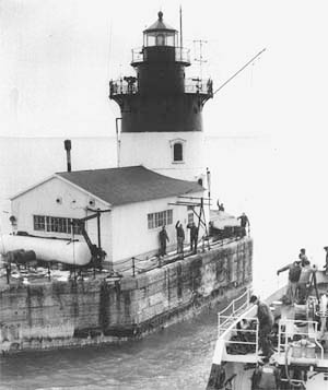
Built in 1885 to guide mariners into the Detroit River, the lighthouse is Coast Guard owned and thus not accessible to the public, and can only be seen by private or charter boat.
This isolated station was not well-liked by Coast Guardsmen, who called it "The Rock." The lighthouse is seven miles from Gibraltar and 28 miles from Detroit. |
| Characteristic and Range: | Two white flashes every 6 seconds |
| Description of Tower: | Conical cast iron |
| Open to Public? | NO |
| Directions: | Accessible by boat only |
| Stamp location: |
Grosse Ile History Museum |
Address: |
25022 E River Rd |
| City: |
Grosse Ile Township |
State: |
MI |
| Zip Code: |
48138 |
Phone: |
(734) 675-1250 |
| Hours: |
Thursday 10a-12p and Sunday 1p-4p |
Admission/Donation: |
$0.00 |
| Web Address: |
www.gihistsoc.org |
Email Address: |
gihistsoc@gmail.com |
| Stamp available by mail? |
Yes, with your photo of the light, SASE & donation sent to: PO Box 131, Grosse Ile, MI 48138. |
